


Le Moussau-Ouchamps (variante)

leeho
User
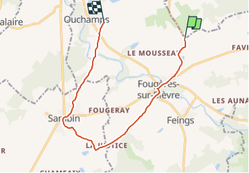

Length
12 km

Max alt
122 m

Uphill gradient
98 m
Km-Effort
13.3 km

Min alt
78 m

Downhill gradient
96 m
Boucle
No
Creation date :
2014-12-10 00:00:00.0
Updated on :
2014-12-10 00:00:00.0
45m
Difficulty : Easy

FREE GPS app for hiking
 SityTrail
IGN / Geographical institutes
SityTrail Plus
The world is yours!
About
Trail Cycle of 12 km to be discovered at Centre-Loire Valley, Loir-et-Cher, Le Controis-en-Sologne. This trail is proposed by leeho.
Description
Variante itinéraire 1
Positioning
Country:
France
Region :
Centre-Loire Valley
Department/Province :
Loir-et-Cher
Municipality :
Le Controis-en-Sologne
Location:
Fougères-sur-Bièvre
Start:(Dec)
Start:(UTM)
376110 ; 5258170 (31T) N.
Comments